percorsi d'Anaunia 140 km
between nature, history and culture
in the heart of Trentino South Tyrol
 percorsi d’anaunia
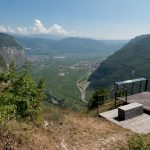
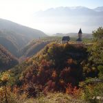
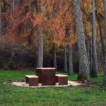
 Torre di visione
- Easy
- h 1:45 / h 0:45
The convenient and semi-leveled trail develops through shady and dense beech woods close to the underlying orchards. After crossing a valley with an ancient bridge in stone and lined by the Maso della Pozza, you reach the fork of the forest road rising from the Masi of Vigo (approximate distance 600m).
 castel san pietro
- Medium
- h 2.30
From the sports ground of Vigo di Ton, the course of the Rinassico stream is crossed and then for a light ascent of a small road we drive forward along the Valle del Rinassico.
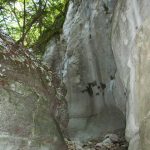
 val ciucina
- medium
- 30 min
Short tour aimed at observing a striking natural curiosity formed by the mouth of the rocky stream of Rio Val Ciucina whose clear waters are frequently populated by salamander.
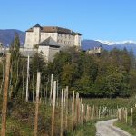
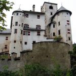
 castel thun
- medium
- 50 min / 30 min
Destination of the walking is one of the most preserved Castles of the Trentino, rich in history, portraits, porcelains, glasses and carriages. The trail starts from Vigo di Ton or from Toss
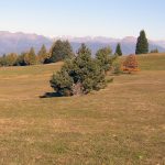
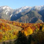
 mas del mont
- medium
- h 2.00
An interesting dotted stretch here and there of large cherry trees, in a panoramic position between the dense pine forests and spruce of the Vervò mountain, at an altitude of 840 m.
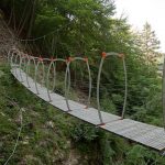
 sentiero romano
- difficult
- h 1.30
The trail begins off the Church of St. Martin, and crosses an adventurous bridge suspended by chains, outside the precipice, along the course of the torrent Pongaiola.
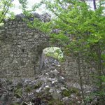
 castel bragher
- easy
- h 2.0
This stretch of trail, with minor undulations, is an 6 Km route through the open fields, woodland and forest . Ideal for all mountain bikers who want to enjoy exploring the Val di Non
 sette fontane
- easy
- h 1.30
An easy trail that links Vervò and Sfruz through Tavlin and Somassolo fir woods, with the possibility to reach the Predaia – Sores locality. The route is ideal for mountain bike.
 lac del bosc
- easy
- h 2.00
The trail takes you to the provincial road of Predaia, just upstream of the new equipped area for camper parking (reachable via a narrow street lying along the provincial road); by taking the convenient forest road that goes on the left you reach the picnic area in the larch meadows little upstream of the old sports field of Tres
 sentiero dei cavai
- medium
- h 1.30
This walk takes in some of the beatiful picnic with recreational area at 835 m above sea level. From here, on a flat forest road (some of them Roman), you enter the pine forest and it is a worth place to visit
 sette larici
- medium
- h 1.30
You can reach the scenic resort Ciasazza (near the ski lifts, at an altitude of 1252 m above sea level - near the restaurant and large meadows) on the slopes of the Predaia (little traffic) southwards, towards Vervò. The opposite direction leads to the Sette Larici (restaurant and wide equipped clearings for the resting stop) which can be reached in less than half an hour
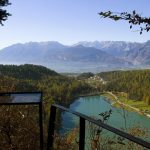
 crosare
- easy
- h 1.30
loop in the pine forest of Smarano locality Crosare. You reach two panoramic terrace with remarkable views. The first over the lakes of Coredo, in the middle Val di Non and in the background the Group of the Brenta Dolomites; the second panoramic point on the wild Valle del Verdès and sanctuary of San Romedio
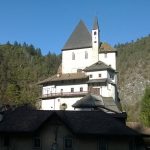
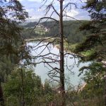
 san romedio
 valli del verdes
Walking along this trail you can admire the white spruce that appear in peculiar associations, different from those found in other places in the Alps. The trail is of great interest because of the presence of animal species, typical of the Alps, which find here suitable conditions for reproduction.
 malachino
- Mittel
- h 5.00
The richness of fauna is related to the nearness of orchards. Territories in the margins of crops serve as a shelter for a multitude of animals who take advantage of their proximity to human activity and find shelter in the thick of the woods.
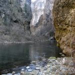
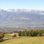
 santa giustina
- Middle
- 3,5 h
This unsurfaced trail follows the torrent Noce and then takes you, through a variety of the habitats within the forest, to the gorge “Forra di Santa Giustina”.